Monday, September 1, 2014

Little Harrison Lake


Elevation Profile
to Little Harrison Lake
This week's hike was one I've been thinking about since last summer. Just South of our district, Little Harrison Lake sits nestled in a secluded basin in Sandpoint's district of the Idaho Selkirk Mountains. Although no trail to the lake exists, it can be reached via a moderate scramble over the ridge from Beehive Lake. Because this lake is harder to reach than many others, it offers more seclusion than it's very popular older-sibling, Harrison Lake.

Mountain Ash
Once again, Justin joined me for this trip and we set out Saturday morning. According to the forecast, weather for the weekend was mostly cloudy with no apparent threat. When we reached the Beehive Lake trailhead on the Pack River Road, we were dismayed to see 5 other vehicles already there. Although we assumed most of them would be at Beehive Lake, I was worried that maybe one or two of the groups might have scrambled over to Little Harrison. The idea of sharing the small lake with a couple noisy-groups really made me grumpy and after contemplating whether to stay or find somewhere else, we decided to take our chances and go for it.

Beehive Lake
The 3.7 miles to Little Harrison Lake consist mostly of steep switchbacks that wind uphill to Beehive Lake. When we reached the lake, we were pleased to find a number of (noisy) groups camped out. Hoping that the owners of all the vehicles were staying at Beehive, we left the trail and pushed up the steep ridgeline separating the two lakes. After completing the 2,400 foot climb from the trailhead to the ridge, we were treated to fantastic 360 degree views of the rugged Selkirk Mountains.

Little Harrison Lake
Panorama from Ridgeline
Little Harrison Lake
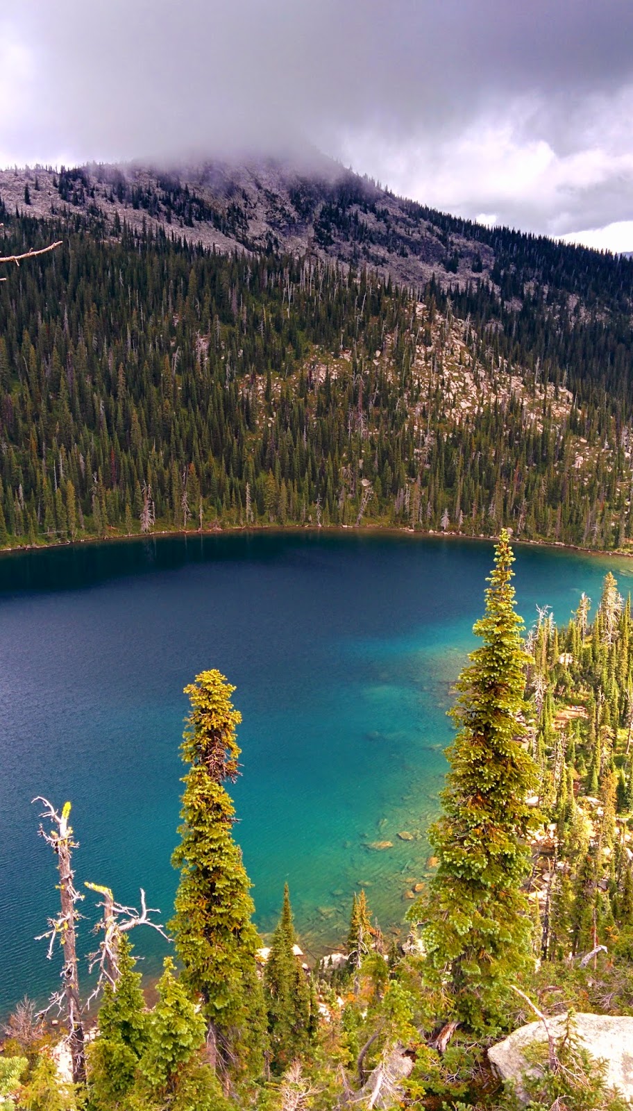
Little Harrison Lake seems to sit in a bowl of pure granite, giving it a deep-blue sapphire color unlike that of the other lakes within the Selkirks. I had gazed upon it during a trip to Beehive last summer and instantly knew that I would return to scramble down to the hidden gem. From the ridgeline, we could see that there was no one at the lake and so in high-spirits we dropped the roughly 500 feet down boulders and cliffs to the water below.

Little Harrison Lake
Harrison Peak
After finding a spot on the granite slabs along the Northern shore, we set up camp and built a fire. Although it was still overcast and some clouds were low on the surrounding peaks, we left our rainflys off, hoping that it might clear up and we'd get to view some stars. It cleared up just as we went to sleep and we did see stars, however just like at Snowshoe Lake, we were woken up by the pitter-patter of rain around midnight and we both scrambled to get our gear covered.

Little Harrison Lake
Sunset
Sunrise on Little Harrison Lake

Sunrise on
Little Harrison Lake
Sunday morning, we awoke to a sunrise with whispy clouds. Although the warmth of the sun felt good, it was cold out and the light was spotty as the sky once again clouded up. Our plan for the morning to was to traverse the high-elevation basins between us and Harrison Lake, summit Harrison Peak, hike down the Harrison Lake trail, and then road-walk back to Beehive Lake trailhead. After packing up, we climbed out of camp and began following the bottom of the ridge North. The hiking was fairly-easy for an off-trail trek, as we crossed subalpine meadows scattered among large fields of boulders, all while the high cliffs and granite slabs of the ridge towered above us. Throughout the journey, the rain and strong winds came and went as the weather fought to make up it's mind.

Meadow above
Little Harrison Lake
We covered the 2 mile traverse in roughly 3 hours and found ourselves standing on the ridge above Harrison Lake. Very high cliffs stood between us and the trail below and as we attempted to route-find our way down, we kept hitting sheer-drops. Up until this point, the trek had been not much more than a moderate scramble, but now were unsure as to how we would get down. After finding a cliff with a set of ledges that we hoped we would be able to down-climb, things got a little scary. I went first by scooting down my butt on a steep slab of mossy-granite with little to hang on to. Bracing with basically only my feet, I got to the bottom of the slab which then dropped into an even-steeper grass slope, with more cliffs below it. Unsure of what the route in the cliffs below the slope was like, I lowered myself down in the grass and clawed my hands into the dirt. After a slippery and exposed descent of the grass slope, I found myself standing on a narrow ledge of rock above another 30 feet of vertical cliff with no further way down. Justin too slid down the granite slab and watched from the ledge above the grass slope as panic set in and we considered our options. Not knowing if it was even possible to climb back up the slab we had butt-scooted down, Justin gave it try. After a few minutes he yelled down that he had made it and after calming myself down, I pulled my way back up the grass. Heart racing, I reached the top of the grass, however I was unable to find a hand-hold and pull myself back up and over the lip of the first slab. Justin once again worked his way back down to the ledge, braced his feet and was able to pull me up and over. As we slowly inched-backwards up the slab, it began to rain again, making the situation even more dangerous. Fortunately, we made it back to the top of the rock and took a few minutes to sweat-out the adrenaline and reconsider our route. We headed back uphill and cut south, finding a much more mellow path down the cliffs.

Little Harrison Lake

Harrison Lake with
Harrison Peak
in Clouds above
When we finally reached the Harrison Lake trail, Harrison Peak was hidden in the clouds. The rain was still coming in regular intervals and after the cliff incident, we decided we had had enough and it was time to go. So we set out down the trail and hiked the couple miles down the road to the car.

I have visited many of the backcountry lakes in the Selkirk Mountains within the Bonners Ferry and Sandpoint Ranger districts and Little Harrison is one of, if not the prettiest. This place is incredibly beautiful and the remote/hard-to-reach location ensures a good chance of finding solitude.

Monday, August 25, 2014

Lost Buck Pass

Elevation Profile:
Trailhead to Upper Lake
Elevation Profile:
Upper Lake to Lost Buck Pass


It's been a couple of very wet weeks up here in Idaho and although the forecast called for more of it this last weekend, I was anxious to get out. Justin and I made plans to once again visit the Cabinet Mountains Wilderness in Montana to explore a feature called Lost Buck Pass and so we set out Friday morning.

Cabinet Mountains Wilderness
Upper Geiger Lake
Lost Buck Pass sits above the Geiger Lakes in the South East section of the wilderness. Rain clouds continually came and went, however we began the hike with hopes of clear skies. The trail enters the wilderness and immediately passes the lower Geiger Lake at around 1.5 miles. This easy to access area gets a large amount of use and it was disappointing to see a couple dozen names carved into the wilderness sign. Another 1.5 miles further brings you to the upper Geiger Lake where we set up camp. Clouds loomed just above the lake, blocking the view of the surrounding peaks and the pass.

Lost Buck Pass,
Upper Geiger Lake
Trail South from Pass
Upper Lake from Pass
Wanless Lake from Pass
Wanless Lake
The next morning, it had stopped raining and the clouds had lifted from the pass. Temperatures were chilly and although the skies looked dark in every direction, they were broken up by fragments of sunshine. Climbing toward the pass, our legs and feet quickly became drenched from the rain-soaked brush along the trail. When we reached the pass, the wind was howling but the views were incredible. From the pass, one can see Wanless Lake West across the valley, towering above the much smaller Buck Lake. Despite the wind and threatening clouds, we followed the trail South from the pass for a couple miles. This trail follows the ridgeline and provided great views with plenty of huckleberries. When it looked like the storms in the distance might head our way, we decided to get down from the high-exposure to the safety of our forested-campsite. That evening, the skies looked much nicer so we decided to hike the 1.5 miles back up to the pass to watch the sunset.

Lost Buck Pass
Trail South from Pass
Upper Lake from Pass
Upper Lake
Lost Buck Pass,
Upper Lake

Sunday morning, the skies were clear but temperatures were still low. After packing up camp, we spent some time exploring the lower lake in the beautiful morning light. Even though we had a great time, this was not the wilderness experience I was hoping for. Certainly the scenery was spectacular despite the weather, but the presence of people took away from the solitude. In all, we saw probably 20 other people in groups ranging from noisy-older women to younger guys with excessive firepower. As I said before, this area is easy to access and seems to attract the rowdy locals. I still highly recommend the scenery, but don't expect to be alone.

Lower Lake

Lower Lake

Upper Lake
Lost Buck Pass

Thursday, August 21, 2014

Volunteer Trail Work

Trail maintenance is hard, physically demanding work that requires passionate people who are willing to get dirty. Because funding for trail work is extremely limited, we rely on help from the many volunteers who come out throughout the summer. Without these people, a lot less work would get done and the trails here would not be in the great condition that they are.

This is a video made by trail crew member Scott Rulander. He shot the footage at our last camp near West Fork Lake in the Selkirk Mountains, while working with Sierra Club and Montana Conservation Corps. Scott is an incredible film-maker and you can view more of his work at: 


Monday, August 18, 2014

This is Trail Maintenance: part 4

This week, I present another trail work video. This video includes footage of day trips and our last camp with the Sierra Club and the Montana Conservation Corps. Enjoy.


Saturday, August 9, 2014

Nothing.

Sorry followers but I do not have anything to post this week. The crew leaves early tomorrow morning for work camp and therefore my weekend was once again cut short. I hope to have some new content for you next weekend!

Tuesday, August 5, 2014

Snowshoe Lake and Snowshoe Peak

Snowshoe Peak from Granite Lake 2013
This week's trip was one I had been planning on and looking forward to for a long time. Last summer I made a single trip over to the Cabinet Mountain's Wilderness in Western Montana, to visit an incredible place called Granite Lake. Instantly awestruck by the CMW, I knew I had to explore it even more. Granite Lake sits below the rugged 4,000 foot vertical face of the mountain "A" Peak. Right next to A Peak is Snowshoe Peak, the highest mountain in the Cabinet Range. At the time, Snowshoe caught my eye and presented a challenge I couldn't let go of. So, I planned to summit Snowshoe Peak because I am a man and men must stand on mountains.

When I presented the idea to my fellow trail crew member Justin, he agreed that it sounded like fun and we set off East Friday morning. First stop, Booze 'n Bait in Troy, Montana to pick up a fishing license. After one stop shopping for liquor, guns, and fishing supplies, we were on our way South towards the trailhead.

The trail begins at what used to be a road that led to the trailhead. Water has since washed out parts of the road and therefore you must now hike the 2 miles extra. This makes for a 7 mile hike to Snowshoe Lake with an elevation gain of 3,823 feet. The first 4 miles are fairly well-maintained trail that follows a creek through damp-cool forests and hot-open berry patches. During my online research before the trip, I had read that the final 3 miles were what was called a "manway". Not really knowing what this meant, I shrugged it off as probably a trail that was a bit rugged.

The "manway" was not a trail. We now know that "manway" basically means that no official trail was ever really built and therefore a faint path through the brush is visible from others who have bushwhacked through. These 3 miles included incredibly thick brush, dozens of downed trees, hidden tripping hazards, super-steep slopes, washed-out ground, a bee-sting, and a final climb up an exposed rock-face.

Snowshoe Lake
Snowshoe Lake
After a short hike up from the top of the rock-face, we arrived at the Lake and came across 2 big horn sheep taking a drink. They watched us for a few seconds and returned to the upper rocks, leaving us to find a campsite. Snowshoe Lake sits on a shelf above a valley at 6,143 feet, with Snowshoe peak at 8,738 feet to it's Southeast. We found our campsite right next the lake's inlet, which comes directly from the melting snow at the base of Snowshoe peak. The mosquitoes were thick and we set up our tents without rainflys, hoping to catch the stars on the clear night. At 10:30 pm, I awoke to the pitter-patter of raindrops on my tent and arose quickly to throw on the rainfly, as did Justin.


Snowshoe Lake
Basin above lake

The next morning we started off toward the summit around 8:30 am. I read online that the 2,595 feet of gain to the peak was somewhere around 3 to 3.5 miles. Leaving the lake, we climbed a hill and found ourselves in a wilderness wonderland. This high-elevation basin above the lake was a paradise of green-grassy meadows, littered with boulders the size of houses. A half dozen small streams from the melting snow above converged there to create the raging creek that feeds the lake. Islands of lush wildflowers of almost every color were broken up by veins of rocks of all varying sizes. And it all gently slopes higher and higher until it turns to nothing but stone and rises to the top of Snowshoe peak.

Snowshoe Lake
The Chute
The route I had researched led us up to the Snowshoe Peak ridgeline via a narrow chute bordered by cliffs. Unfortunately, this chute was still holding a massive piece of snow. Feeling like we could get around it, we started the climb up the loose talus slope. We decided we could climb the cliffs to the left of the chute, if we could just get up and over the first high cliff. To do this we either had to A.) traverse the steep snow chute from the right side without ice axe or crampons, or B.) claw our way up the bergshrund, which is the location where the snow pulls away from the rock wall. We chose B, which also included a small waterfall flowing over the top of the crack, directly where we needed to go up. The steep ascent to the head of the crack was made even scarier with the water that soaked the rocks, however I managed to climb part way up and find a hand-hold to pull myself up and over. As Justin came up, he was unable to reach the hand hold I had used and so I held out my trekking pole for him to grab and pulled him up as well. Soaked and relieved, we continued up the large wet slabs of rock toward the ridge above us.

Looking south from the ridge
Looking up the ridge towards the peak

Snowshoe Peak summit
Ridgeline
Upon reaching the ridge, we were greeted with magnificent views in all directions, including a good look at the rest of our trek toward the top. The ridgeline provided a fairly non-technical but sometimes steep hike to the summit, which we reached around 11:00 am. On the summit, we were greeted with 360 degree views of the wilderness area. Mountain tops in every direction towered above lakes 4,000 feet below. There was a lot of air on the peak because of the way all the sides seem to just drop right off into nothing but scenery. A menacing front of clouds loomed to West and we heard thunder, so after only a short time on top, we decided to get back down to the much-less exposed lake. When we reached the dreaded area where we climbed up through the crack, neither of us wanted drop down it backwards. Looking for another way, we decided our only option was to traverse the snow chute and hike out in the bergshrund on the right side of the chute. Without ice axes or crampons, a slip and fall would mean a very long, fast slide to the rocks below. But, we took it slow, kicking in solid footholds in the solid snow and ensuring our trekking poles were firmly planted with each step. I'd love to say that as a man I had no fear, but that was honestly some scary $#!*.

"A" Peak and Granite Lake
Snowshoe Lake
Leigh Lake
Yellow Columbine, Snowshoe Lake
My fish
By the time we got down, the storm had moved in above us. Fortunately, it brought only light rain in-between periods of hot sunshine. So, I grabbed my fishing pole and quickly began reeling in the cutthroat trout. A couple of hours later and I caught 6 fish however only the first one was worth keeping. That night, we ate the very delicious fish in front of a campfire and watched the lightning storms in the distance. Light rain once again broke into sunny skies for the morning and we hiked out the "manway" to the actual trail.

A trail to this lake does not exist and therefore this is an advanced trip. The remote location, rugged terrain, and lack of access ensure that solitude can be found at Snowshoe Lake, making this wild place feel even more wild. I'm not sure why the Forest Service never completed a trail to the lake, however it keeps all but the most-determined from reaching it, ensuring that it stays natural.

360 degree view from Snowshoe Peak summit
Basin above lake
Hikers

Monday, July 28, 2014

This is Trail Maintenance: part 3

Once again, I failed to get out backpacking this weekend because work camp cut my weekend short. So this post includes part 3 of my trail work videos. Footage in this video was shot entirely at our work camp this last week.

Camp took place at Hidden Lake in the Selkirk Mountains. The entire week consisted of the construction of a new trail to a summit called Red Top. The trail that already existed was never officially built, just used over and over again by horse packers. So although a faint path existed, we built an entirely new tread. We first began this project at a work camp last year and were able to add on about a mile of new tread this last week. A mile of hand-tooled trail is a great distance to travel in the course of only one week and we couldn't have done it without the group that joined us, Volunteer Vacations.

Although the weather started promising with sun and mild temperatures, by mid-week, on and off rain made conditions a bit damp but not unpleasant. Then storms blew in and Thursday quickly became my worst trail-crew day to date. Pouring rain, with intermittent hail, cold temperatures, howling wind, and thick fog made for an extremely miserable day. The crew was wet and slightly demoralized, but Friday turned out to be a much better day.

That's it! In general, camp was great except for one bad day. I have a trip very exciting trip planned for this weekend, so hopefully the weather holds out and I can get a new trip-report up.