Monday, July 28, 2014

This is Trail Maintenance: part 3

Once again, I failed to get out backpacking this weekend because work camp cut my weekend short. So this post includes part 3 of my trail work videos. Footage in this video was shot entirely at our work camp this last week.

Camp took place at Hidden Lake in the Selkirk Mountains. The entire week consisted of the construction of a new trail to a summit called Red Top. The trail that already existed was never officially built, just used over and over again by horse packers. So although a faint path existed, we built an entirely new tread. We first began this project at a work camp last year and were able to add on about a mile of new tread this last week. A mile of hand-tooled trail is a great distance to travel in the course of only one week and we couldn't have done it without the group that joined us, Volunteer Vacations.

Although the weather started promising with sun and mild temperatures, by mid-week, on and off rain made conditions a bit damp but not unpleasant. Then storms blew in and Thursday quickly became my worst trail-crew day to date. Pouring rain, with intermittent hail, cold temperatures, howling wind, and thick fog made for an extremely miserable day. The crew was wet and slightly demoralized, but Friday turned out to be a much better day.

That's it! In general, camp was great except for one bad day. I have a trip very exciting trip planned for this weekend, so hopefully the weather holds out and I can get a new trip-report up.


Saturday, July 19, 2014

This is Trail Maintenance: part 2

This weekend I present part 2 of my trail maintenance videos. The smoke in the mountains around Bonners Ferry really obscured the views and my weekend is cut short because we go into work camp Sunday morning. So I did not get out with my backpack and therefore do not have a new trip report.

This video includes footage of the crew at work camp, building wooden-walkways, hand-tooling tread, brushing and logging with the Montana Conservation Corp, and sawing trail on our 2 day/1 night "spike".

Parker Ridge
Parker Ridge
The following pictures are from the spike which was this last Wednesday and Thursday. We do this because certain trails within our district are very long and easier to saw out in a 2 day push. These are long days and long miles carrying a chainsaw, however the trails include some of the best scenery in our district. These photos are from Parker Ridge, the trail our group of 5 was sawed out. Enjoy!

Parker Ridge
Long Mountain Lake on Parker Ridge
Granite Wall
Mountains obscured by smoke from the Washington fires


Tuesday, July 15, 2014

Fault Lake

Elevation Profile
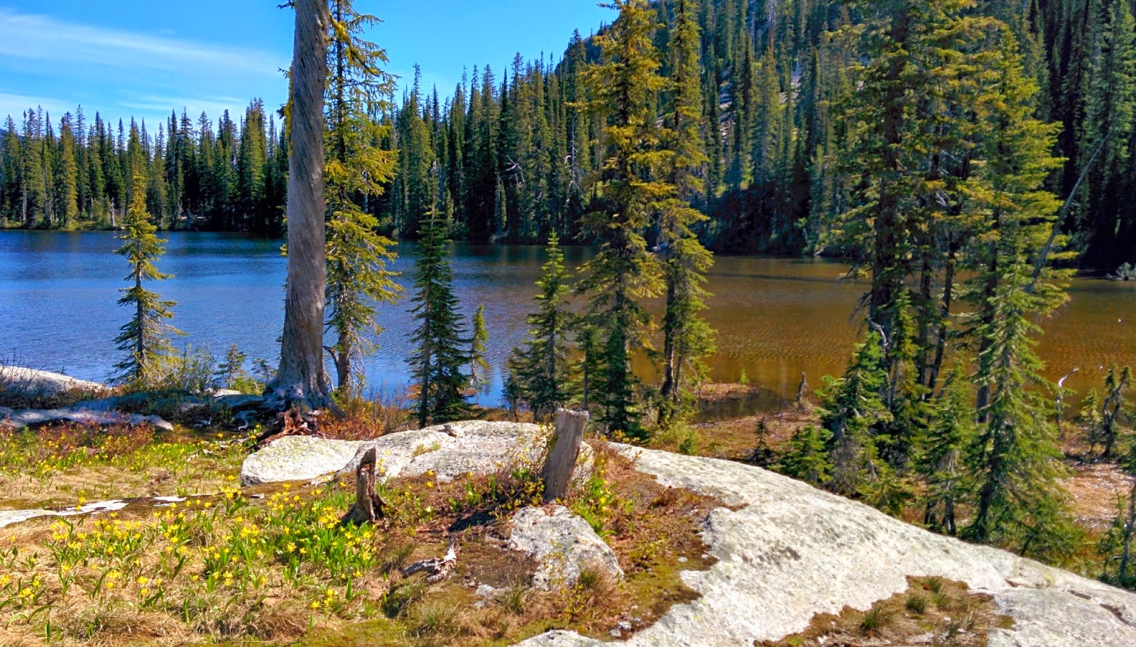
Sorry this is a short post, but I've had a very busy week due to busy days and various camps. Although my usual 3-day weekend was cut short due to a work camp, I still managed to get out and spend Saturday night at Fault Lake. This beautiful lake sits at 5,980 feet in the Sandpoint Ranger District of the Idaho Selkirks. Gaining around 2,900 feet of elevation over 5.8 miles, the trail climbs from the Pack River into a subalpine wonderland that holds the lake in a large granite cirque below Hunt Peak.

A peek at higher elevations
Getting closer to the high-country
Halfway up the rough road that leads to the trailhead, I was stopped by wash-out ruts half the size of my little car. So, I parked on the side there and began the extra 0.8 mile road walk to the trailhead. When I got to the trailhead, I was not thrilled to see 6 vehicles parked there! Not the night of solitude I had in mind. A half-hour into the hike, I ran into a group of 10 high-school aged friends slowly on their way up the trail. They let me pass and I hiked on not knowing much about the lake and how it would accommodate so many people. I also noticed fresh tracks along the trail from a visibly large group of horses. All of this left me second guessing my plan, but I was already in to it and not turning back.

Really opens up around mile 4-5
Fault Lake from the south
Near the 5 mile mark, I ran into a group of 3 camped out in a meadow below the lake. They told me the group of horse riders were only up for a dayhike and that there was plenty of space at the lake. The lake was spectacular and I quickly found a campsite on a ledge above the rocky shore. I proceeded to explore the ridgeline to the south of the lake and caught a glimpse of McCormick Lake on the other side. By the time I got back down, the 10 person crew had shown up and the horse-riders were leaving.
McCormick Lake

Fault Lake

Campfire on my ledge
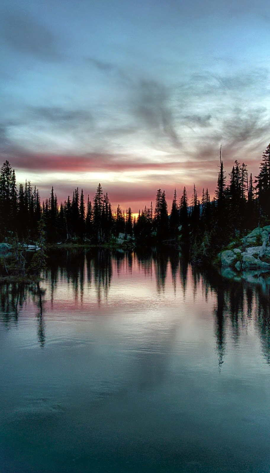
Full moon rising
I was very worried at first when the large group made a lot of noise while swimming and throwing rocks in the lake. However, as the sun began to dip down, the group retreated to ridgeline I had explored earlier and although I could see the light of their fire, I could not hear them and therefore had a very peaceful time. Just like clockwork, as the sun dipped down in the west, the full moon came up in the east. Very few clouds loomed in the sky, providing a great view of the moon and stars.


Sunset to the east
Fault Lake

Fault Lake

An unnamed pond
Fault Lake from the north
The next morning, I woke up early and explored the ridge to the north of the lake. A short scramble to the top provided great views of Gunsight Peak and Fault Lake from a different angle. After that, I packed up and hiked out.


The outlet falls below the lake
Fault Lake


Sunday, July 6, 2014

Two Mouth Lakes

I am happy to say that I finally have a full backpacking-trip report for your enjoyment. The weather cooperated and allowed me to get out on this holiday weekend. No fireworks for me though; just the sparks from a campfire in a place I consider to be paradise. This weekend's excursion took me to Two Mouth Lakes in Idaho's Selkirk Mountains, one of my top five favorite campsites from last summer!

My elevation profile
Water on trail
The trail to Two Mouth Lakes climbs about 1800 feet over the course of 4 miles. For the first 3/4 mile, the trail follows an old road that is hot/dry and overgrown with alder. It climbs steadily through forests of western hemlock, subalpine fir, and Englemann spruce. There is even a section with some of the largest western white pines I have ever seen, with one roughly 4 1/2 to 5 feet in diameter. Being that there is still a substantial amount of snow in the highest reaches and temperatures are hot, there was seasonal runoff everywhere. After about the first mile, water covered much of the trail whether it was flowing like a stream or just overly swampy/muddy. Even through the sections with wooden walkways, water flowed up and over with no place to go. Fortunately, I wore a pair of Gore-Tex shoes and my feet stayed dry as I sloshed right through.

Snow before the pass
Southwest from the pass
As the trail neared the pass at the 3 1/3 mile mark, I hit heavy snow. The higher elevation area still contained patches 2 to 4 feet deep. However the trees began to thin out making navigation much easier, just slow-going as I kicked in steps uphill. Once on top of the pass, views of the surrounding area really opened up, including a fantastic view of Harrison Peak. From there, the trail descended gently towards the two lakes. 

Looking across lower lake outlet
Two Mouth Lakes sit in a large, marshy basin at around 5800 feet. The two very pretty lakes are surrounded by subalpine fir, Englemann spruce, and even some whitebark pines. The trees here tend to be stunted and twisted from the high elevation/wet conditions and are well spaced making the basin feel more open and viewable. Giant boulders are intermingled with grassy areas, dotted by marshy pools and flowing-water lined with huckleberries, round-leaf violets, and glacier lilies. If I were a moose, this would my home. This area is designated official grizzly bear habitat but unfortunately I did not see one or any wildlife for that matter. Small patches of snow were scattered throughout the basin, but not so much as to prevent me from finding a dry spot to pitch my tent.

Waterway connecting upper and lower lakes
Lower lake outlet
West across lower lake
Sunset on lower lake
Upper lake
There was no one at either of the lakes when I arrived and that night I enjoyed the the lower one all to myself. Friday morning I awoke to the sun peeking over the trees, announcing that the weather for the day would be clear. I had packed enough food for two nights and decided to leave my camp and explore the surrounding area. First, I made the short 1/2 mile trek to the upper lake which  is larger than the lower, but not as scenic in my opinion. It lacks the quaint-grassy feel of the smaller more marshy lower lake where I prefer to camp. At the base of the peaks to the south of Two Mouth Lakes, there sit two more lakes known on my map simply as lake 6291' and lake 6321'. Neither one of these name-less lakes has a trail to it and I decided it be worth the trouble to bushwhack up to these rarely-seen gems. The trek to these lakes includes a climb of about 600 feet over 1 1/2 miles. The majority of the climb was on the north aspect of a hill and therefore was almost entirely over snow. The snow actually made the hiking easier as it kept me elevated above the brush and provide good solid footholds. I wore my crampons and used my trekking poles which made the trip much easier. The lower lake sits in a granite cirque below a name-less peak and the snow-surrounded water was still mostly frozen. The larger upper lake, which sits in the cirque at the base of Harrison Peak was almost completely thawed out. Harrison Peak is a very recognizable feature in the southern Selkirks and I hope to summit it eventually from the other side. Even with the snow, the trip to see these remote lakes was well worth it.

Lake 6291'
Lake 6291'
Harrison Peak above lake 6321'

Sunset lower lake
My campfire
That evening, a number of other hikers arrived at the lower Two Mouth Lake. Although it was no longer my own "private" lake, they were courteous and quiet and I still had a very enjoyable 4th of July as I watched the sunset. It may sound dumb and cliche, but to me personally, wilderness is what America is all about. These places offer freedom from the problems of the modern world and a chance to live more simply, if only temporarily. I hope that future generations will understand that the land is one of the factors that makes this country great and we must leave some of it wild.

"In every walk with nature, one recieves far more than he seeks." -John Muir

Waterway connecting upper and lower lakes
White mountain heather along shore of lower lake
Red, white, and blue sunset on lower lake
Waterway connecting upper and lower lakes
My campsite